Iceland’s southern area includes two of the country’s most famous tourist routes: the South Coast and the Ring Road as well as the most beloved areas of the Highlands. With so much to offer, it’s not surprising that many visitors spend their entire visit in South Iceland.
With so much beauty in this region alone, visitors don’t need to travel much further unless they want to! In this article, you’ll find a brief introduction to each major natural attraction and must-visit place in South Iceland. We have another separate article about practical travel information to this region.
Regions in South Iceland
There are four major areas in South Iceland:
- The Golden Circle Route
- The South Coast
- The Southern Highlands
- The Westman Islands

The Golden Circle Route
The Golden Circle Route leads around some of Iceland’s most famous geological features. This is a geothermal zone with frequently spouting geysers, a gigantic waterfall, and a UNESCO site where you can walk inside the crack between the tectonic plates. There are plenty of stops along this tour route but the three most famous are listed below.
Thingvellir National Park
As we mentioned above, Thingvellir National Park is a UNESCO World Heritage site where Icelandic history and outstanding geological wonders come together. Thingvellir is the historic place where the law speakers stood up and proclaimed the law a millennium ago. This was the location of the world’s very first parliament, founded in 930 AD.
The folks in the old times didn’t know it at the time, but Thingvellir is also where the tectonic plate boundaries are displayed most impressively in the form of a beautiful, rugged rift valley. Another fun fact is that this rift valley in Thingvellir was a filming location for one of the episodes of Game of Thrones.

Geysir Geothermal Area
The famous Geysir Geothermal Area is probably the most popular natural attraction in all of Iceland. A highly active geothermal field stretches for hundreds of meters and steaming ground, boiling hot springs, and spouting geysers surround its visitors.
The famous Stori-Geysir, also known as the Great Geysir, is the inspiration behind the English word “geyser”. This geyser is sadly inactive today but its smaller neighboring geyser, Strokkur, erupts every 5–8 minutes.

Gullfoss Waterfall
The third main stop on the tour route is the gigantic waterfall, Gullfoss, meaning the “Golden Falls” in English. The water in these falls comes directly from Iceland’s second-largest ice cap, Langjökull glacier.
The cascade plunges a total of 32 m (105 ft.) in two stages. This first step is 11 m (36 ft.) and the second is 21 m (69 ft.), ending in a canyon that is 70 m (229 ft.) deep. When the weather is cooperative, the spray around these falls takes on a golden hue and you can sometimes see a rainbow shining over the water. This is why this site earned the name of the Golden Falls!

The South Coast
The South Coast is just as popular as the Golden Circle route and just as frequently traveled. The area on the Ring Road from Hveragerdi to Vik is referred to as the South Coast. Some websites and tours may include Skafafell and Jokulsarlon Glacier Lagoon as part of the South Coast. Officially, this section belongs to Southeast Iceland, which is part of East Iceland.
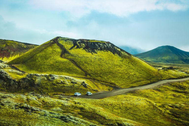
On the South Coast, rugged mountains, mossy lava fields, quaint little farms, and tiny villages will provide an idyllic backdrop for your road trip. Several major volcanoes such as Hekla, Katla, and Eyjajfjallajökull are also visible from the main road. There are tons of interesting places and natural attractions along the coast, but the most famous ones are as follows.

Seljalandsfoss and Gljúfrabúi Waterfalls
One of the major attractions on this tour is Seljalandsfoss, which is one of Iceland’s most famous waterfalls. It sits at the foot of Eyjafjallajökull, which is also the source of the water for the cascade. You can take the path behind the waterfall if you’re visiting in summer. This path tends to freeze over in winter, though, so you’ll usually find it off limits.

Near Seljalandsfoss is a hidden waterfall named Gljúfrabúi. This especially scenic waterfall is located in a crack in the wall just five minutes’ walk from Seljalandsfoss. This one is not for the faint-hearted, be prepared to get soaked!

Eyjafjallajökull Glacier-Volcano
Further east along the South Coast, you’ll find the world-famous Eyafjallajökull volcano. Covered in a thick layer of glacial ice, this memorable site is actually a 1651-m (5417-ft) volcano. Eyafjallajökull gained worldwide notoriety in 2010 when it disrupted global air travel due to its most recent eruption. Read more about the volcano in this article.

Skógafoss Waterfall and the Skogar Museum
Tumbling down 18-story cliffs, Skógafoss Waterfall is the next gorgeous sight. Found not far from Seljalandsfoss, these falls have an impressive width of 24 m (78 ft.). You won’t be able to walk behind the cascade here, but you can walk up close to the base to feel the spray on your face. You also have the option of climbing up to the top to see the cascade from above.

Skógafoss has appeared as a filming location for a number of TV shows, such as Vikings and Game of Thrones. This waterfall is considered to be one of the most beautiful in the country, which is saying a lot.
According to the legends, back in the 10th century, a Viking hid a treasure chest behind the waterfall. There it remained for centuries until one lucky person saw the chest and tried to grab it. The only part he was able to grab before it disappeared was the golden ring on the side of the chest, which broke off in his hand. This golden ring didn’t disappear and can still be seen today in the Skógar Museum as proof that this legend is true. It sits alongside other items in the folk museum and cultural heritage collection.

Mýrdalsjökull and Sólheimajökull Glaciers
When you visit the South Coast of Iceland, the most characteristic parts of the landscape are the blue ice falls and the impressive glacier tongues. The first of these glacier tongues that you’ll come across as you head eastward is Sólheimajökull, one Mýrdalsjökull’s rugged outlet glaciers. Katla Volcano hides under this ice cap, which is 700 m (2296 ft) thick. This volcano is due for an eruption sometime soon. Read more about Myrdalsjokull and Solheimajokull in this article.

The Plane Wreck on Solheimasandur Beach
In November 1973, a Douglas DC-3 aircraft from the US Navy was forced to crash land on the black sands of Iceland with seven crew members on board. Luckily, no one was hurt in the accident even though the crew reported near-death experiences.
There’s no consensus on what went wrong. Some say that the plane ran out of fuel because the pilot used the wrong tank while others say it was a mechanical failure. In either case, the plane was left on the sand where it landed. No one has ever tried to recover it.
Today, despite the fact that a 1-hour walk is needed to get there, the site is one of the most visited attractions in the area. You can find so many photos and videos from here, both on social media and even in commercials on TV. This wreck seems to have a mystical quality to it, aided by the isolated and desolate location it’s found in.

Dyrhólaey Stone Arch
Offering a 120-m (393.7-ft) promenade with stunning 360° panoramas of the South Coast as a whole, Iceland’s Dyrhólaey Peninsula is a famous site. There is a rock arch that shares the same name, Dyrhólaey, which means “Door Hill Island.” It’s also well-known for its abundance of birds and its historic lighthouse. In the summer, you can find thousands of puffins and other Arctic seabirds living here.
Reynisfjara Black Sand Beach
The famous Reynisfjara Black Sand Beach is one of the most visited places in Iceland. Its thrilling rock formations, hidden caves, outstanding sea stacks, and long, black sand coastline enchants everyone who sees them! These thrilling cliffs are home to the cute Atlantic puffins from May to August. Reynisfjara was listed among the ten most beautiful non-tropical beaches in the world by the National Geographic!

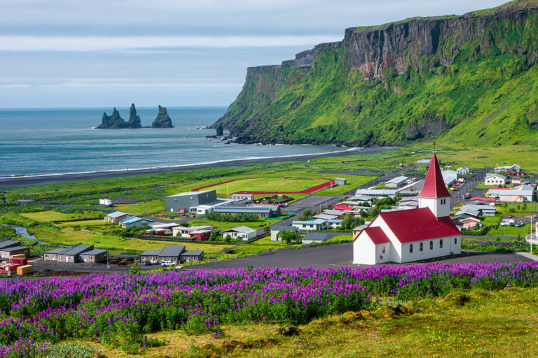
Vík Village
Vík í Mýrdal is a quaint little village with its own black sandy beach and a spectacular view of the Reynisdrangar sea stacks. The town has an idyllic little church that sits on the top of the hill, looking down on the village. The view from here is absolutely fantastic. Vík is an important service center in this region, offering a range of accommodation, restaurants, and other tourist services.

Fjadrargljufur Canyon
Near the village of Kirkjubæjarklaustur in Southeast Iceland is a breathtaking canyon named Fjadrargljufur. The canyon was not well-known to visitors until a few years ago when Justin Bieber shot a few scenes here for his music video for “I’ll Show you.” Bieber was instrumental in introducing Fjaðrárgljúfur to other travelers. The number of visitors to the canyon has increased by 60–80% since the video was released.
The sheer walls of this gorgeous canyon twist and turn over 2 km (1.24 mi.). Measuring 100 m (328 ft.) deep, this canyon is home to a sleepy river that slowly snakes its way to the sea. The canyon is filled with salients in strange shapes, bumps, and patches of soft grass and moss. All of this comes together to create a vision straight out of a fairytale. The experience of standing at the top of this hidden jewel is one that you’ll definitely never forget!

The Southern Highlands
Inland and further from the coasts are the Icelandic Highlands, a vast uninhabited tundra wilderness. The area can be accessed from June to September by large 4×4 vehicles. In winter, it can only be accessed by guided Superjeep tours.
The Southern Highlands in particular are a favorite among both photographers and hikers. Many of the most impressive of Iceland’s natural gifts can be found here accompanied by the silence and serenity that only untouched nature can offer.
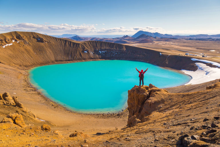
Landmannalaugar
The entire Landmannalaugar region is dotted with rhyolite mountains. The colorful pictures of these photogenic mountains have become very popular on Instagram. This is one of the best regions in the country for those who like hiking, bathing in hot springs, or both! There is a large number of hiking trails in Landmannalaugar, which is also the starting point for the renowned Laugavegur trail. Over four days, this trek will take you from Landmannalaugar to Thorsmork.
Any trip to Landmannalaugar would be incomplete without enjoying a peaceful swim in a natural hot spring. The huge thermal pool here is the perfect temperature for bathing: 36–40°C (96–104°F). So make sure that you bring your bathing suit and towel with you when you visit!

Thorsmork
Þórsmörk, whose name means the “Valley of Thor,” is a valley which lies peacefully between three glaciers: Mýrdalsjökull, Tindfjallajökull, and Eyjafjallajökull. This scenic gem is one of the most popular locations for photographers, hikers, and nature lovers thanks to its jaw-dropping scenery.
The unique terrain here is full of contrasts. Lush oases, black deserts, and lively glacial rivers all coexist in a place like none other on Earth. If you want to visit, you can get to Thorsmork on a day tour from Reykjavik, either on a guided Superjeep tour or by renting a car and driving yourself. If you choose to drive yourself, keep in mind that you’ll have to cross many rivers to get there.

The Westman Islands
The Westman Islands archipelago, also known as Vestmannaeyjar, lies off the south coast of the country. Of this collection of 15 islands and 30 rock stacks, only one is inhabited. Heimaey, which is also the largest of these islands, has more than 4000 inhabitants. While humans may not inhabit the other islands, the animal world does. In summer, these islands have the largest population of nesting puffins in the world.
The Westman Islands are famous for their natural beauty and their history. In 1973, Eldfell Volcano erupted, forcing a complete evacuation and destroying a number of buildings. This incident brought Vestmannaeyjar worldwide fame. You can learn more about this famous volcanic eruption here.