West Iceland has a beautifully varied landscape full of volcanic craters, impressive mountains, rugged lava fields, dramatic coastal cliffs, and tiny seaside hamlets. Iceland’s vibrant capital area is located in this region, as well as some of the scenic tour routes that Iceland is so famous for. In this article, you’ll learn about West Iceland’s most beautiful natural attractions and the places you should definitely visit if you are traveling in the area.
Regions in West Iceland
There are four major areas in West Iceland:
- The Snaefellsnes Peninsula
- Borgarfjordur
- Breidafjordur
- The Capital Region
You’ll probably spend some time in the capital area, at least a night or two after your arrival and the same before you leave. The Snaefellsnes Peninsula is the most easily accessible from Reykjavík since you can drive around the peninsula and get back to the capital in just one day. The same applies to Borgarfjordur while Breidarfjordur is a bit further from Reykjavik. Though also in the west, the Golden Circle, the Westfjords, and the Reykjanes Peninsula officially belong to separate regions.
In this article, you’ll find practical information about West Iceland’s weather, road conditions, and infrastructure, and you can read about its history and geology briefly.

The Snaefellsnes Peninsula
Despite its great location relatively close to Reykjavik, the Snaefellsnes Peninsula is an underrated tourist destination but this unique area provides amazing opportunities to explore Iceland’s remote countryside and scenic, off-the-beaten-path destinations.
The road that circles the peninsula can be driven in just one day and the route contains examples of every type of beauty that Iceland has to offer: glaciers, volcanoes, black beaches, waterfalls, and so much more.
Where Is Snaefellsnes Located? How Do I Get There?
Snaefellsnes, whose name means “Snow Mountain Peninsula,” is a 90-km (56-mi) long peninsula located in West Iceland, about 150 km (93 mi.) north of Reykjavik. The peninsula is one of the most exciting areas in all of West Iceland and one of the most popular tour routes within a day’s drive of Reykjavik. The peninsula is named after its main attraction: a majestic, cone-shaped volcano crowned with a glacier. One of Iceland’s three national parks is located here and is also named after the volcano.

What Are the Best Ways to Get Around?
You can either drive around the peninsula in a rental car or join a guided tour. Both options are safe and fun, so it’s up to you to decide which one fits you best. We’ve written another article to help you plan your holiday to Iceland where you can read more about choosing your travel style.
Guided Tours
Guided tours generally depart from Reykjavik and the capital area. Guided trips include the transfer as well as an English-speaking driver/guide who will share all kinds of interesting facts and stories about the area during the drive.
Tours last about 10–12 hours with plenty of stops along the way. The length of the stops vary from 20–40 minutes, but can sometimes be even longer. This is more than enough time to explore the attractions, take photos, and enjoy the views.
Self-Drive Tours
Snaefellsnes is easily accessible for independent travelers as well. If you’re driving a rental car, take Road 1 (the Ring Road) from Reykjavík, heading north. In Borgarnes, change to Road 54 and follow it until you reach the peninsula. There’s only one road that circles around the peninsula, so it’s hard to get lost.
From Reykjavik, it takes about two hours to reach Snaefellsnes, but driving all the way around the peninsula and visiting the natural attractions will require a full 10- to 12-hour day. For this reason, it’s best to split the trip into two days during the winter, when the daylight periods are very short.
It’s worth noting that Snaefellsnes, being a peninsula, is quite windy in the winter and the road conditions aren’t always the greatest. Roads can be snowy and icy. If you’re not experienced driving in winter conditions, please consider taking a guided tour instead, where skilled local guides will take care of your safety on the road.

Public Transportation
Visiting Snaefellsnes by public transport isn’t the best idea. There’s only one direct bus to Stykkisholmur, which departs from Reykjavik three times a week. The problem is that this bus doesn’t drive around the peninsula and doesn’t make any stops at the natural attractions. If you can’t or don’t want to drive, your best option would be to take a guided group tour.
What Are the Top Attractions on Snaefellsnes?
The Snaefellsnes Peninsula is so full of things to see that it has earned the nicknames “Iceland in Miniature” and “Iceland in a Nutshell.” With a selection of all the natural gems Iceland is known for, Snaefellsnes offers you a one-stop option to see a volcano, a glacier, lava field, waterfalls, caves, craters, picturesque mountains, fishing hamlets, towns, and villages. The coastline is simply gorgeous, covered in beaches with both gold and black sand, rugged rocks, and frozen trolls being hit by the constant waves of the Atlantic Ocean.
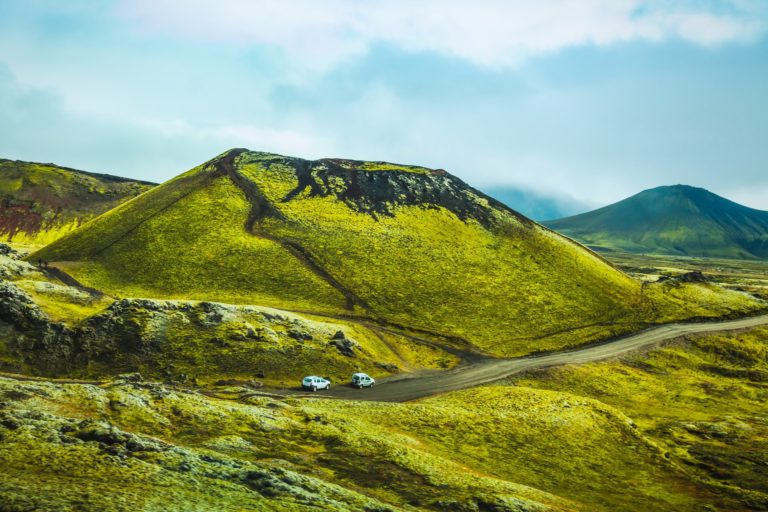
Eldborg Crater
Starting on the south side of the Snaefellsnes Peninsula, the first exciting attraction will be Eldborg Crater, which you’ll easily be able to see from the road. Getting to the crater will require a small detour from Road 54.
Eldborg, the “Fortress of Fire,” is an impressive volcanic crater rising 60 m (197 ft.) above the surrounding lava field with a diameter of 200 m (656 ft.). Today, it’s a sleeping volcano, so it’s absolutely safe to visit. In fact, the last eruption happened about 6000 years ago. The hike up to the volcano and around its crater is about 6 km (3.7 mi.) in length. It will take around two hours to hike both ways, depending on your walking speed.

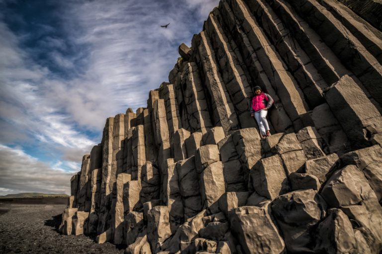
Gerðuberg Basalt cliffs
Gerduberg is a protected nature reserve that’s home to a massive wall made of 15-m (9-ft) tall hexagonal basalt columns. This is one of the most impressive columnar joint formations in the country. The perfect geometric patterns dominate the landscape for about 500 m (1640 ft.), offering an absolutely wonderful view in every direction.
The best way to see the cliffs is to walk right in front of them and head to the top. If you want to see this natural piece of architecture up close and personal, there’s an old walking path that passes just by the columns. The most impressive view is from the top, though, so don’t miss out! You can get to Gerðuberg easily from Road 54 and it’s just a few minutes to get from the parking lot to the cliff itself on foot.

Ytri Tunga Beach
Ytri Tunga is a golden sand beach near an old farm on the south coast of Snaefellsnes. The beach is famous for being one of the most reliable places in Iceland to see seals. If you do want to see the seals, make sure to visit in the summer. This is definitely the best time for seal watching. You can expect to see grey seals and calf seals since these are the most common species on this beach. If you look at these in profile, it’s easy to tell them apart. The grey seal’s head is large with a long snout that draws a nearly straight line from the forehead to the tip of the nose.
In the car park, you’ll find signs that also explain the types of seals that you can expect on the beach. After leaving the car park, you’ll arrive on the sandy and grassy shore. Once here, look at the horizon closely for any signs of seals. They are normally far away from the shore, on the side, which is why you should take some binoculars if you want to have a better view.

Budir Church
Búðir is a small hamlet consisting of a few buildings in the middle of an extensive lava field near the sea coast. The site used to be a vibrant fishing village and one of the most active trading posts on the peninsula. Medieval sources, along with archaeological evidence, suggest that human activity here can be dated back to the time of the settlements, but the trading post was abandoned completely at the start of the 19th century.
Today, Budir is most famous for its highly picturesque black church. This small church, Búðarkirkja, sits in an awe-inspiring setting and so it seems like it’s in the middle of nowhere. The first church on this spot was built in 1703. The current building was built in 1848 and reconstructed in 1987. Its pure black paint makes it a very popular object for minimalistic photography. There’s also an upscale country hotel nearby, making the location ideal for weddings.

Rauðfeldsgjá Ravine
Rauðfeldsgjá, the “Red-Cloak Rift,” is the next gorgeous must-see natural site to add to your list. This is a thrilling gorge in a cliff face with a stream running through it. The good news is that when you visit here, a bit of climbing will take you to a small waterfall. The bad news is that if you want to go further in than the waterfall, you’ll need to be fully equipped with waterproof clothing and sturdy shoes. You’ll also have to be reasonably fit and mentally prepared to get pretty wet. Please note that for safety reasons, you should not attempt this route at all if the ground is icy.
You’ll find this gorge on the south side of the peninsula. From the main road (Road 54), you need to take Road 674 in the direction of Hellnar. It’s hard to miss the enormous crack in the face of the mountain coming out of Snæfellsjökull glacier. When you get to the parking lot, it will take about 20 minutes on foot to get to the base of the gorge. From there, you can climb inside, following the stream of glacial meltwater. You can also go to the side of the ravine where you’ll have a better view of this beauty after a 10- to 15-minute climb.

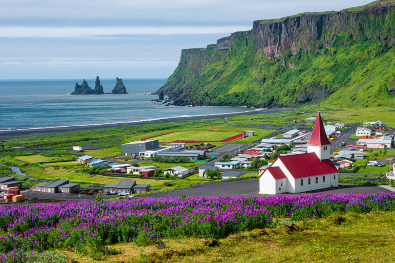
Arnarstapi and Hellnar
Arnarstapi and Hellnar are two small hamlets a few kilometers apart on the south coast of Snaefellsnes. Both of them used to be busy fishing villages and important trading ports with thriving communities. Today, there aren’t many year-round inhabitants, but the villages are filled with tourists in summer.
The rugged basaltic coastline that connects the villages was made a natural reserve in 1979. The landscape here is perhaps the most beautiful in the entire peninsula with black basalt columns and thrilling seaside cliffs with rifts, hollows, and plenty of species of birds nesting in the rocks. Tiny fishing boats decorate the small natural harbors and the spectacular views stretch out in every direction.

The Lóndrangar Basalt Cliffs
Lóndrangar is a pair of sea stacks that look like a huge castle. These stacks rise 61 m (200 ft.) and 75 m (246 ft.) above the sea. An array of seabirds nest in these cliffs during the summer, including puffins and fulmars. According to local legends, trolls and elves also live in these rocks.
There’s a parking lot near the cliff where a viewpoint was built. This viewpoint offers the perfect vista over the basalt pillars surrounded by rough lava and the rocky shore on its eastern side. It’s also possible to hike up close to the sea stacks from another spot that lies further west, starting near the lighthouse. The hiking path starts in the parking lot and takes you right to the base of the pillars.

Vatnshellir Cave
Vatnshellir is one of the highlights of Snaefellsjökull National Park. This 8000-year-old lava tube is over 200 m (656 ft.) long and reaches down to 35 m (115 ft.) below the surface. Inside the cave, there are two main sections: an upper and a lower part. Both sections offer unique lava sculptures, stalactites, stalagmites, and colorful volcanic formations.
Guided tours are offered at the location, lasting 45 minutes each. Visitors are equipped with safety gear before a skilled caving expert guides the group through the cave. The path is easily walkable and there’s no need for crawling. The ground is sharp and uneven, so sturdy hiking boots are necessary. The cave is located just 10 minutes by car from the village of Hellnar, right next to the road.

Djúpalónssandur and Dritvík Beaches
The black sand beaches of Djúpalónssandur and Dritvík are the second most-famous black beaches in Iceland, coming right after Reynisfjara. Djupalonsandur is packed with strange volcanic basalt formations that create an otherworldly atmosphere.
The black coast is decorated with smooth pebbles of all sizes. Some of them are so big that local fishermen used them to test their strength in olden times. A 54-kg (199-lb) rock was the minimum test of the fishermen’s strength. If they couldn’t lift it, they weren’t allowed to become fishermen.
You’ll also come across the iron ruins of a British trawler that became shipwrecked east of Dritvík Cove in 1948. A total of 14 men died at sea, but five were successfully saved by the local search and rescue teams. The pieces of the ruins that can be found littering the beach remain as a memoir of the lives lost here and so shouldn’t be removed or taken away.
Just like at Reynisfjara, the sneaker waves on these beaches are life-threateningly dangerous for visitors. So you must make sure to keep a safe distance from the water and never turn your back on it.

Snaefellsjökull Glacier
Snaefellsjökull is a dormant volcano crowned by an impressive glacier. It’s 700,000 years old and rises to an impressive 1446 m (4744 ft.) above sea level. This glacier is the main attraction in West Iceland, dominating the landscape all the way across the entire peninsula. Its name is made of the words Snæfell (“Snowy Mountain”) and jökull (“Glacier”). The volcano last erupted in about 200 AD and has been dormant since then.
Jules Verne might be the person responsible for the popularity of this volcano. In the 1864 novel Journey to the Center of the Earth, Snaefellsjokull is the place where the main characters find the entrance to the passage that will lead them to – you guessed it! – the center of the Earth. Apart from its important place in the history of literature, Snaefellsjökull is a spectacular glacier that offers matchless views of the entire peninsula.
Some people believe that this site is the home of the heart chakra of the Earth and that, therefore, the glacier gives off a unique energy field. So, keep your eyes and heart open when visiting this photogenic site. No matter what you believe, Snaefellsjokull has been inspiring and fascinating locals and visitors for a long time. You can join a guided glacier hiking and climbing tour to explore the glacier safely.

Kirkjufell: The “Church Mountain”
Kirkjufell, the “Church Mountain,” is one of Iceland’s most epic landmarks. It also might be the most photographed mountain in the country. It’s located on the northern coast of the Snaefellsnes Peninsula. The distinctly-shaped peak, rising 463 m (1519 ft.) above the sea, is such an impressive sight that it’s often used on postcards to represent all of the beauty of Iceland.
To make this striking view even more memorable, there are two beautiful waterfalls close to the mountain. A short walking path takes you from the parking lot to the viewpoint where you can see the waterfalls at the perfect angle in front of the mountain. No wonder this setting is so popular with photographers! Kirkjufell is a wonderful photo location all year round, regardless of if it’s the midnight sun or the Northern Lights painting the skies in beautiful colors.
Kirkjufell had a starring role in the HBO series Game of Thrones. The mountain was a shooting location in multiple scenes in Season 7, representing the northern landscape “Beyond the Wall.”

Grundarfjörður Village
Grundafjörður is a small village that’s located right next to Kirkjufell with a small population of about 900 people. The village offers a wonderful view of the mountain from almost every street and every house. There has been a newfound interest in this village recently, which is growing in popularity thanks to how near it is to Kirkjufell. This town is a gathering point for all of the photographers from around the world that visit this area just for the chance to photograph the gorgeous peak.
The fame of this village, apart from its proximity to the peak, should be no surprise. Like its neighboring mountain, this village has had a role in many films, including The Secret Life of Walter Mitty, which you should definitely watch before your trip to Iceland. The village has a few small restaurants, cafés, and some guesthouses as well. Some of the activities available in the area include golfing, kayaking, and hiking. Each of these will reward you with breathtaking views and memorable experiences.

The Berserkjahraun Lava Field
Stretching between Grundarfjörður and Stykkisholmur villages, Berserkjahraun is the most impressive lava field on the Snaefellsnes Peninsula. It was formed during a volcanic eruption about 3000–4000 years ago. These craters are still visible, rising over the lava field. One is Rauðkúla, the “Red Crater,” which is 379 m (1243 ft.) wide, while the other is Grákúla, the “Gray Crater,” which is 211 m (629 ft.) wide. Although both craters are actually red, Grákúla appears grey because of the moss covering its slopes.
The lava field was named after a story in the Eyrbyggja Saga. This saga tells us about a farmer who had two laborers from Sweden working for him back in the 10th century. Also known as Berserkers, these men were infamous for being large and aggressive. As is to be expected, the farmer’s daughter captured the heart of one of the men. When the man asked the farmer for permission to marry his daughter, the farmer wanted to say no but he was afraid of how the Berserker would respond, so he asked the local chieftain what to do. The chieftain suggested that the farmer give his daughter’s suitor an impossible task to complete. So, the farmer told the man that he could marry his daughter if he forged a road through the lava field, to save the farmer from having to go all the way around when he wanted to get to the other side.
After agreeing to the task, the Berserker and his friend got straight to work. Thanks to their size and strength, they were able to finish quite quickly. When he saw that the road was almost complete, the farmer was very happy that he would soon be able to cross the field easily, but he was also afraid that this man would soon be his son-in-law. So, one day after work, the farmer invited the men into a special sauna to relax. This turned out to be a trap. The farmer killed both men and buried the bodies.
Nowadays, this road still crosses Berserkjahraun and the suspected burial place can still be seen. After excavating the site recently, archeologists found the remains of two large men. This makes us wonder if this story from the saga could really be true!

Stykkishólmur Village
With a population of 1100 people, Stykkishólmur is the largest town on the peninsula. It was created by merchants from Denmark and Norway, who built the town around the natural harbor. Now, this is a very picturesque fishing town filled with colorful buildings from the end of the 19th century.
The nearby landscape is very photogenic with a promontory that looks out over the beautiful bay of Breiðarfjörður. When you visit this charming town, you can go to cozy cafés, learn about the local culture, visit the volcano museum, and taste freshly-caught shellfish. There is also a ferry that crosses over the bay, heading for Flatey Island and the Westfjords.

Borgarfjordur and the Silver Circle
Borgarfjordur is famous for its agriculture, so you’ll find farmlands and greenhouses everywhere. With the Icelandic sheep and horses peacefully grazing in the fields, it should be no surprise that the Lonely Planet chose Borgafjörður as one of its “Top 10 Regions To Visit in 2016.”
Icelanders love this area for its beautiful landscapes and good hiking trails. Locals have spent summer holidays and weekend outings here for decades, so there are plenty of summerhouses in the area.
Where Is Borgarfjordur Located? How Do I Get There?
Borgarfjordur fjord is located near the town of Borgarnes in West Iceland, 80 kilometers north of Reykjavík. The area stretches 50 kilometers further towards the inland, all the way to Husafell.
What Are the Top Attractions in Borgarfjordur and the Silver Circle?
Borgarfjordur is home to the popular tourist route called the Silver Circle. This route is composed of 4–5 main stops: Deildartunguhver (the most powerful geothermal hot spring in Europe), the magical Hraunfossar Waterfalls, the historical Reykholt village (where the writer Snorri Sturluson was born in the 13th century), Vidgelmir (the greatest lava cave in Iceland), and Langjokull (the country’s second-largest glacier), all of which are located near Husafell.
Deildartunguhver Hot Spring
Deildartunguhver is Europe’s most powerful hot spring in regards to hot water produced. It provides 180 L (47.5 gal-) of boiling hot water per second, which is then used for heating up the homes in the towns of Borgarnes, Akranes, and the surrounding farms. If you take a shower anywhere within a 65 km radius of the spring, you have already bathed in the hot water from this powerful spring!
Hraunfossar Waterfalls
Hraunfossar, “the Lava Falls,” are a rare natural phenomenon, even in Iceland. Cold glacial water springs out of the lava and creates a míriad of tiny waterfalls and rapids that cascade into a stunningly blue river. The series of waterfalls cover the cliff about 900 meters (2950 ft) long. The water originates from Langjökull glacier and the water runs into the famous Hvítá river which is also the source of the famous Gullfoss waterfall.

Reykholt Village
Reykholt is a tiny village with a great history. It was the home of the legendary Icelandic historian, poet, and politician: Snorri Sturluson. He was twice elected lawspeaker to the Icelandic parliament, the Althing, and was also the author of Iceland’s famous Eddas and some very valuable historical books. Thanks to these works, we now know how the Vikings and the kings of what is now the United Kingdom interacted, how the clans and jarls quarreled, and how their governments were formed; governments that still exist today.
Nowadays, Reykholt is a stunning little town that is definitely worth visiting. It’s home to Snorralaug geothermal pool, one of the oldest structures in Iceland, and has a very pretty church, too.
Vidgelmir Cave
Víðgelmir Cave measures 148,000 m3 (3.55 cu mi.), making it the largest cave in Iceland as well as one of the largest lava caves on Earth. Inside this cave, you’ll find lava stalactites, stalagmites, and some stunning ice formations.
In 1993, some Viking-age jewelry and bones were found in the cave as part of an archaeological investigation. Since then, entrance to the cave has been restricted, so you’ll only be able to enter as part of a guided tour. You’ll have the option of a short, 1.5-hour tour or a longer, 4-hour tour. Scientists consider Víðgelmir to be one of the most remarkable caves of its kind in existence. So, no matter which tour you choose, you’re sure to be amazed.

Husafell
Within the region, Húsafell holds special fame for its spectacular hiking trails and its pleasant microclimate. With mountains that protect it from the wind and Langjökull glacier standing guard above, the highest temperatures on the island are often found in Húsafell. The area around Husafell is full of waterfalls, glaciers, dense forests, wildflowers, crystal-clear springs, rugged lava, and some interesting historic and archaeological relics.
Breidafjordur
Breiðafjörður is the second-largest fjord in Iceland, found in the north part of the Snaefellsnes Peninsula. It measures about 70 km (43.5 mi.) at its widest and 125 km (77.6 mi.) at its longest. This fjord separates the Westfjords from the rest of the country.

Where Is Borgarfjordur Located? How Do I Get There?
The fjord is located about 170 km from Reykjavik, north of Snaefellsnes. Throughout the year, the Baldur Ferry crosses this fjord, traveling from Stykkisholmur in the south to Brjánslækur in the north. In summer, it even offers stops at Flatey island. Taking the ferry is a great way to explore the beautiful bay and its islands.
What Are the Top Attractions in Breidafjordur?
One interesting geological feature is that the northern part of the bay was formed about 15 million years ago while the southern end of the fjord is half as old. The fjord is relatively shallow in many places and there are about 2800–3000 little islets littered all over the bay. These were formed by the force of the glaciers during the ice age periods.
Flatey island
Some of the bigger islands were once inhabited and the island of Flatey was even home to a monastery. Today, almost all of them are uninhabited or abandoned, except for Flatey, which remains the only island in Breiðafjörður where inhabitants live year round.
These islands are home to rich flora and fauna. Large puffin colonies live there along with 50 other species, including brent goose, eider, and black guillemot, but the king of the skies here is the white-tailed eagle. The waters are full of herring and other fish along with shellfish. These rich feeding grounds attract toothed whales such as orcas, dolphins, and porpoises. Occasionally, even minke and humpback whales show up in the bay.

Budardalur village
The largest settlement in the fjord is Budardalur, a small village with about 270 inhabitants. It has a long history, which dates back to the time of the settlements. This was the place where the first settlers set up a temporary camp when coming to the area.
The Capital Region
The Capital Region refers to Reykjavík and its neighboring towns: Mosfellsbaer, Kopavogur, Hafnarfjordur, Garðabær, Seltjarnarnes, and Kjósahreppur. Today, this area is home to about 60% of Iceland’s total population (about 220,000 people), in spite of taking up less than 1% of the country’s landmass. Although these are all different towns, they’re connected to Reykjavík, forming a large, continuous capital area.
Founded in 874 AD, the first people to settle in the area gave the spot a name that meant “smoky bay,” in reference to the steam escaping from the nearby hot springs. Up until the middle of the 18th century, Reykjavik was nothing but a collection of houses and farms. The Danish king donated Reykjavik to a Danish-owned company in 1752. After that, the father of Reykjavik, Skuli Magnusson, established wool workshops there, which allowed the trade of this small town to begin to expand and thrive.
In the 20th century, Reykjavík was already a vibrant town when British and American troops invaded Iceland during WWII. While stationed in the country, the American troops were able to help Reykjavík with its development. The city increased its infrastructure and opened its first bars and restaurants. By investing in both culture in sports, this capital city took its first steps towards modernity.
There are plenty of great places to explore in the capital area. The old town, which you can find in downtown Reykjavík, is filled with colorful, Scandinavian-style houses, souvenir shops, cozy cafés, and great restaurants. It’s famous for its vibrant nightlife.
Fifteen geothermal pools, plenty of forested parks and nature reserves, beautiful coastal walking paths, historic sites, open-air museums, countless art museums, botanical gardens, a planetarium, and so much more are waiting for you in the Capital Region. The surrounding mountains are filled with hiking trails. Mount Esja, outside of Mosfellsbaer, is the most popular hiking area in the capital region and its paths are packed with locals during the weekends when the weather is nice.